

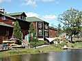
 Camden Maine
A scenic coastal town, full of unique shops, historic homes, and visiting sailboats.
 Camden Hills State Park
"Where the Mountains Meet the Sea", right off US Route 1.
 Rockport, Maine
A small coastal village with a scenic harbor park and one of Maine's best art galleries.
 Rockland, Maine
Home to the country's largest windjammer fleet, and one of New England's most respected art museums.
featured sponsor
Maine Sport Outfitters
Maine Sport Outfitters - Rockport ME
Maine Sport Outfitters is recognized as the premier destination for paddlers, campers, cyclists, skiers, and fishermen for the latest in outdoor gear & clothing. They also also offer a variety of sea kayaking tours on Penobscot Bay.
Maine Sport Outfitters Images
Maine Sport Outfitters is a retail sports outlet store and offers kayak, canoe and bike rentals. They also offer several quality sea kayaking tours and instructional programs.


Maine Sport Outfitters
Route One
P.O. Box 956
Rockport, ME 04856
Toll-free: 888-236-8797
Phone: 207-236-7120
Tours: 207-236-8797
Fax: 207-236-7123
Store Hours
Sept 1 - June 15
9am to 6pm, Mon-Sat
9am to 6pm, Sunday
Summer Hours
June 16 - Aug 31
9am - 8pm, Every Day
Email: Click here
Visit Website
Reviews
Map It


Rockland Maine Hiking - a list of popular hiking trails in and around the Rockland Maine area
The Rockland area offers some of the best hiking in the State of Maine. There are a number of popular hiking trails in the area including hiking venues like Camden Hills State Park and the George’s Highland Path which offer some of the most spectacular coastal scenery and panoramic views in New England. Camden Hills State Park, for example, has roughly 30 miles of hiking trails, which can be accessed from five main trailheads. All trails lead to the summits of either 800 foot Mt. Battie or 1,380 foot Mt. Megunticook and offer sweeping views of Penobscot Bay, the surrounding wooded hills and the rocky Maine coastline. At Camden Hills, the trails are fairly well marked and maintained, there are plenty of access points and public parking is available within the park.
Below we have provided links to various hiking trails ranging from a short 1-mile hike up the face of Mt. Battie in Camden Hills State Park to a 6-mile scenic trek around the island of Islesboro. Check out these unique hiking trails, plan your hiking adventure ahead and have fun exploring the Rockland Maine region.
Hiking Trails around Rockland Maine
Rockland Maine Hiking
Hiking Trails & Venues around Rockland Maine
Trail Type: Out & Back |
Bald Mountain Preserve - Camden, ME Bald Mountain (not to be confused with Bald Rock Mountain in Camden Hills State Park) spans over 600 acres with geologic features that are unique for the area as well as a diverse terrain. The forested area is home to a wide variety of small mammals, birds, black bears, coyotes, and deer. While hiking to the summit of Bald Mountain, everyone is sure to get a glimpse at the local preserve's wildlife. Once at the peak, hikers get arguably the best view of Penobscot Bay and the surrounding Camden Hills. The preserve is a rare blend of wilderness and solitude that can be hard to find on many traditional hikes. Other Related Links Bald Mountain Camden - SummitPost.org |
||
Trail Type: Out & Back |
Bald Rock Mountain - Camden Hills State Park, Camden ME Hiking to the top of Bald Rock Mountain in Camden Hills State Park is one of the most visually stimulating hikes in Maine. While Bald Rock Mountain is much smaller than the popular Mount Megunticook, the view is second to none. The top of the summit opens up into 1,100+ foot ledge with a 200 degree panoramic view towards Penobscot Bay. From the ledge you can get a great view of the nearby Islands of Penobscot Bay including the Ensign Islands, Islesboro, North Haven, Vinalhaven and Isle Au Haut as well as neighboring mountains. The walk up isn't bad either. The trail is well maintained and provides excellent openings to lush greenery as well as always playing host to a variety of local wildlife and birds. Other Related Links Bald Rock Mountain Trail - Trails.com |
||
Trail Type: Out & Back |
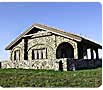
Beech Hill Preserve - Rockport, ME Beech Hill Preserve is a small unassuming hill in Rockport Maine and is considered by many hikers as one of the most scenic yet versatile preserves in Maine. It plays host to multiple trails and routes as well as the only bald hilltop in the area. The trails primarily pass through organic blueberry fields and open grasslands. Many bird watchers walk through the preserve as it was added to the Maine Birding Trail because there are over 100 different species in the preserve. Many visitors stop at "Beech Nut" which is a stone house with a sod roof, that is listed on the National Register of Historic Places, and can easily be seen at the top of Beech Hill. With so many open areas in the preserve, the views are second to none. Hikers can see the entire Penobscot Bay, Camden Hills, and the St. George peninsula. Other Related Links Beech Hill Preserve - CoastalMountains.org |
||
Trail Type: Loop |
Belfast - Belfast, ME OK, this is not really a hike but more of a leisurely village stroll through an historically rich coastal community with a prestigious shipbuilding tradition. Along this scenic hike, visitors will view the old homes of prominent sea captains complete with widow's walks, as well as see the town that once was home to several industrial boatyards. Today, the city of Belfast is in the midst of a cultural and economic renaissance. Belfast hosts the largest selection of galleries in a city its size in Maine, and is home to a vibrant arts community with many artists and artisans living and working in this harbor town. Hiking through the city of Belfast is almost like attending a permanent Arts & Artisans Fair - you are sure to find something unique and creative in this small seaside community. Other Related Links |
||
Trail Type: Out & Back |
Ducktrap River Preserve - Lincolnville, ME The Ducktrap River Preserve is the largest preserve under the control of the Coastal Mountains Land Trust. It already spans over 1135 acres and over 29,000 feet along the Ducktrap River. The Ducktrap River has become a focus of environmentalists and nature lovers alike. It is one of the few remaining rivers that is still a suitable habitat for Atlantic Salmon to spawn. The Ducktrap River Preserve has is a great destination for hikers, skiers, birders, and fisherman alike. While it is privately owned land, it is almost completely open to the public. With its lush natural greenery it has become a favorite for hikes through the dense woods or on any of the trails. There are also trails that lead to excellent skiing opportunities as well as prime fishing. Other Related Links Ducktrap River Preserve - CoastalMountains.org |
||
Trail Type: Out & Back |
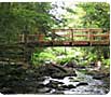
Ducktrap River Trail - Lincolnville, ME Ducktrap River Trail is a great hiking experience. It totals almost 4.5 miles, however, it is not a difficult hike and is considered relatively easy to tackle. The total elevation increase throughout the hike is 120 feet. The Ducktrap River Trail offers hikers a visual spectacle. It hugs the Ducktrap River which winds through the area. The trail loops through a section of the Camden Hills State Park with a forested landscape that is not terribly dense. The trail loop circles an area that has more than a few intersecting trails which offers hikers a chance to choose whether they would like a shorter hike, medium hike, or long hike. During the winter, many cross country skiers enjoy this trail as well as snowshoeing enthusiasts. During the warmer months of the year, many birders come to walk around and see the increasing number of unique birds. At an average pace, the entire trail can be completed in about two hours. The trail ends practically where it starts, as it was designed as a loop. The trail remains open all year round. Other Related Links Ducktrap River Trail - Trails.com |
||
Trail Type: Loop |
Fernalds Neck Preserve - Camden, ME Fernalds Neck Preserve is a protected preserve of beautiful land which sprawls across much of the Fernalds Neck Peninsula, which shoots out into Megunticook Lake. There are miles of walking trails available for the general public that run through a dense softwood forest. There are also many areas where hikers and walkers alike can take in the shores of one of Maine's best small lakes. The preserve itself tends to be overlooked by hikers that are visiting the area which means that you can hike in relative peace and quiet. Additionally, it is so large that it feels like you have a giant stretch of nature to yourself. This preserve is open all year long, however most people try to avoid it during the muddy season because the trails can get very muddy, slippery, and possibly dangerous. Other Related Links Fernalds Neck - Trails.com |
||
Trail Type: Out & Back |
Georges Highland Path - Midcoast, ME The Georges Highland Path that passes through the Ragged Mountain Section in the Camden area is a low-impact hiking path through the high country of the Georges River watershed. It is maintained by the Georges River Land Trust. There are three distinct parts to the Ragged Mountain section of the Georges Highland Path: Mt. Pleasant Farm to Mt. Pleasant Road; Mt. Pleasant Road to the yellow gate at Route 17; and the Thorndike Brook Access Point to yellow gate at Route 17. The Path is marked by blue paint blazes and occasional stone markers. Parking is available along Route 17. Hiking maps and information about the Georges Highland Path are available by calling the Georges River Land Trust at 594-5166 or visiting their offices at 8 North Main Street in Rockland, Maine. Other Related Links Georges Highland Path - GRLT.org |
||
Trail Type: Out & Back |
Hatchet Mountain Preserve - Hope, ME Hatchet Mountain Preserve is one of the newest preserves to open in Maine. It was officially opened on Earth Day, 2009. The trails at Hatchet Mountain Preserve are shorter than many others in the area, as the entire preserve is only 27 acres. However, it is quite steep as it can take you all of the way to the summit of Hatchet Mountain. Once at the summit, you will be standing almost 1,100 feet above sea level. Your trek to the summit will give you a chance to see one of the best views of the Camden Hills right next to Penobscot Bay. A majority of the parcel is covered with stands of red oak and a great panoramic view of the coastal mountains. Other Related Links Hatchet Mountain - CoastalMountains.org |
||
Trail Type: Out & Back |
Hike Around Islesboro - Islesboro, ME Islesboro is a year-round island community, 3 miles out in Penobscot Bay. You can reach the island by taking a state operated ferry from Lincolnville Beach. The year-round population of about 600 swells to a figure several times that in summer, a time when visitors experience some of the best weather in Maine. The island remains largely unchanged from more then a 100 years ago when it became a renown, but informal, resort community. The fabled exclusivity exists because of the island's separation from the mainland, but, in truth, the island is one of the friendliest places around. The island has few commercial concerns. An island hike past stately homes, over a narrow ridge with ocean views on both sides, and around a rocky point with views of the open ocean will take you back to a simpler time. The short walk around the tip of Pendleton Point rivals any of the more renown local mainland venues for majestic coastal beauty. Other Related Links Read Islesboro article |
||
Trail Type: Out & Back |
Maiden's Cliff - Camden Hills State Park, Camden ME The trail leading to Maiden's Cliff is an easy hike with a spectacular view the entire way. The trail itself is just over one mile (officially 1.8 miles) and is moderately steep for the first half mile and then levels out for an easy walk over the second half. During your hike, there is a fork in the road so make sure to read the signs and choose the right path. Otherwise you may find yourself completing a more difficult hike than you set your sights on. At the end of the Maiden's Cliff Trail, you will find Maiden's Cliff, a rock outcropping formation that juts out 800 feet above Megunticook Lake and overlooks Ragged Mountain to the west. At the top of Maiden's Cliff, you will get to experience a vast panoramic view of the surrounding area including a look down at Megunticook Lake and all of its small islands and inlets. You will also be able to see the Atlantic Ocean as well as the surrounding countryside. It is a breath-taking view to say the least. Other Related Links Read Maiden's Cliff article |
||
Trail Type: Out & Back |
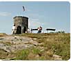
Mount Battie Trail - Camden Hills State Park, Camden ME Mt Battie Trail is a simple trail from the edge of Camden to the top of Mt Battie. What it lacks in length it makes up for in elevation. While it is less than mile hike, the elevation increases 600 feet over the course of the hike. It is a quick hike and can be done in about an hour, however many people take their time and soak in the great views. It is open for hiking from May to November and is one of the most easily accessible trails in Maine. At the top of the trail, an old stone tower sits in silence and is a popular attraction for kids. You will also get a great view of the Atlantic Ocean. The view alone is worth the hike and rivals Mt Desert Island as the “Finest Coastal Hiking Area in the Northeast”. Other Related Links Mount Battie Trail - Trails.com |
||
Trail Type: Loop |
Mount Megunticook Trail - Camden Hills State Park, Camden ME Mount Megunticook is the tallest of all of the Camden Hills. It also is regarded as the highest mainland mountain on the entire Atlantic Coast. One section of the trail, known as the Ocean Lookout gives guests one of the most impressive ocean vistas in the entire Northeast. Mount Megunticook is a great location for hikers of any skill level. While there are great vantage points throughout the hike, the view from the summit is fantastic. The trail is shaped in a loop so the trip down is different than the trail that was walked up. Most hikers complete this journey in around three hours. Throughout the hike to the top, hikers go up over 1,100 feet in elevation. While a majority of the hike is on a trail that has only moderate, but constant, trail elevation, the final push can become quite steep. Other Related Links Mount Megunticook - Trails.com |
||
Trail Type: Out & Back |
Ragged Mountain - Camden, ME Ragged Mountain is a great way to spend an afternoon for anyone that enjoys hiking. In total, it spans just over 2 miles. During this hike you will gain 870 feet in elevation, however with the length of the trail the elevation changes are not as dramatic as it may seem. With a top elevation of almost 1,300 feet, a great view awaits at the summit. You will be able to take advantage of expansive views of both Rockland and Rockport harbors as well as the offshore isalnds of Penobscot Bay. Ragged Mountain Trail can be completed in approximately two hours assuming that you are hiking almost non-stop. However, with the great view and infinite photo opportunities, many people choose to make this trail an afternoon event. Other Related Links Ragged Mountain - Trails.com |
||
Trail Type: Out & Back |
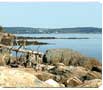
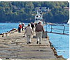
Rockland Breakwater - Rockland, ME A man-made granite breakwater that juts out nearly a mile from the Rockland Harbor shoreline. It was built to protect Rockland Harbor. The Rockland Breakwater offers a nearly 2-mile hike out-and-back with awesome panoramic ocean views and nearly a mile long walk to the Rockland Breawater Light at the end of the pier. Other Related Links Read Rockland Breakwater article |
||
Trail Type: Loop |
Rockport Villlage - Rockport, ME A quaint harbor village, home to the Rockport Opera House, windjammers, a small marine park, and one of Maine's best art galleries - the Maine Center for Comtemporary Art. Rockport is also known for "Andre the seal", the legendary harbor seal who lived and performed here during the 1970s and early 1980s. You can see his statute at the Rockport Marine Park. The Children's Chapel in Rockport is also worth a visit. It is a beautifully landscaped garden spot open to the public, overlooking Penobscot Bay. It is a favorite location for weddings from spring to early fall. Other Related Links Read Rockport article |
||
Trail Type: Loop |
Tanglewood - Lincolnville, ME Hiking at Tanglewood has the reputation for being one of the most relaxing loop trails in the area. It is open year round so everyone can have access to it. Throughout the trail, the elevation change is minimal, which makes the trail one of the easiest trails to walk in the area. During the spring and summer many hikers come out as do the birders. During the fall and winter, snowshoeing is very popular on the trail. Most hikers try to keep an eye on the moisture level in the spring, because early on it can be extremely muddy. Hikers taking advantage of Tanglewood get the experience of hiking in a small valley along a route that is next to a river full of trout and salmon. There are also areas of dense softwood trees as well as overly mature hardwoods. Special fishing regulations have been enacted to protect the salmon that swim by as well as the native brook trout. However, when the salmon are running, it really is a sight equal to nothing else. The main river that runs through Tanglewood is the Ducktrap River. Other Related Links Tanglewood - Trails.com |
||


Hiking Gear & Accessories
Maine Sport Outfitters TF: 888-236-8797 |
Maine Sport Outfitters - Rockport, ME Maine Sport Outfitters is recognized as the premier destination for paddlers, hikers, campers, cyclists, skiers, and fishermen for the latest in outdoor gear & clothing. Maine Sport Outfitters is a retail sports outlet store and offers kayak, canoe and bike rentals. They also offer several quality sea kayaking tours and instructional programs. Services: Hiking Gear & Accessories |
||
Location Map of Rockland Maine Area Hiking Trails

Click on map to open a new browser window with a Google Interactive Map of all area hiking trails in the Rockland Maine region.